Benin's Geography
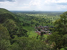
Atakora, one region of Benin
Benin, a narrow, north-south strip of land in west Africa, lies between the Equator and the Tropic of Cancer. Benin lies between latitudes 6° and 13°N, and longitudes 0° and 4°E. Benin is bounded by Togo to the west, Burkina Faso and Niger to the north, Nigeria to the east, and the Bight of Benin to the south.
With an area of 112,622 km2 (43,484 sq mi), Benin extends from the Niger River in the north to the Atlantic Ocean in the south, a distance of 650 km (404 mi). Although the coastline measures 121 km (75 mi) the country measures about 325 km (202 mi) at its widest point.
It is one of the smaller countries in West Africa, one-eighth the size of Nigeria, its neighbor to the east. It is, however, twice as large as Togo, its neighbor to the west.
Benin shows little variation in elevation and can be divided into four areas from the south to the north, starting with the low-lying, sandy, coastal plain (highest elevation 10 m (32.8 ft)) which is, at most, 10 km (6.2 mi) wide. It is marshy and dotted with lakes and lagoons communicating with the ocean. Behind the coast lies the Guinean forest-savanna mosaic covered plateaus of southern Benin (altitude between 20 and 200 m (66 and 656 ft)) are split by valleys running north to south along the Couffo, Zou, and Oueme Rivers.
Then an area of flat lands dotted with rocky hills whose altitude seldom reaches 400 m (1,312 ft) extends around Nikki and Save. Finally, a range of mountains extends along the northwest border and into Togo; this is the Atacora, with the highest point, Mont Sokbaro, at 658 m (2,159 ft).
Benin has fields of lying fallow, mangroves, and remnants of large sacred forests. In the rest of the country, the savanna is covered with thorny scrubs and dotted with huge baobab trees. Some forests line the banks of rivers. In the north and the northwest of Benin the Reserve du W du Niger and Pendjari National Park attract tourists eager to see elephants, lions, antelopes, hippos, and monkeys.
Benin's climate is hot and humid. Annual rainfall in the coastal area averages 1300 mm or about 51 inches. Benin has two rainy and two dry seasons per year. The principal rainy season is from April to late July, with a shorter less intense rainy period from late September to November. The main dry season is from December to April, with a short cooler dry season from late July to early September. Temperatures and humidity are high along the tropical coast. In Cotonou, the average maximum temperature is 31 °C (87.8 °F); the minimum is 24 °C (75.2 °F).
Variations in temperature increase when moving north through a savanna and plateau toward the Sahel. A dry wind from the Sahara called the Harmattan blows from December to March, during which grass dries up, the vegetation turns reddish brown, and a veil of fine dust hangs over the country, causing the skies to be overcast. It also is the season when farmers burn brush in the fields.
